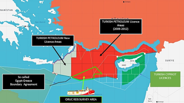
Turkey's Foreign Ministry shared a map Monday showing the offshore survey activity of its seismic research vessel Oruc Reis within the country's continental shelf and borders of its Exclusive Economic Zone (EEZ) in the Eastern Mediterranean.
"The Oruc Reis launched its offshore survey activity today in the Turkish Continental Shelf declared to the UN. Greece makes a big fuss over this activity," said Cagatay Erciyes, a senior Turkish Foreign Ministry official.
Erciyes said on Twitter that Greece has created problems because of a 10-square-kilometer (3.86-square-mile) Greek island named Kastellorizo which lies 2 kilometers (1.24 miles) away from the Turkish mainland and 580 kilometers (360 miles) from the Greek mainland.
"Greece claims 40,000 km2 of maritime jurisdiction area due to this tiny island and attempts to stop the Oruc Reis and block Turkey in the Eastern Mediterranean.
"This maximalist claim is not compatible with international law. It is against the principle of equity. Yet Greece asks the EU and US to support this claim and put pressure on Turkey to cease its legitimate offshore activities. This is not acceptable and reasonable," he said.
Erciyes stressed that these countries should instead ask Greece to stop its unjust, inequitable and absurd claims.
"It is Greece, not Turkey who creates tensions in the area due to such maximalist claims," Erciyes said.
Erciyes in his Twitter post also shared information on the maritime jurisdiction areas and how they should be delimited based on the principle of equity.